Applespring & Camoo
The Lower Bridge River Canyons

Photo: Mike Cleven
Aerial pic from Photos by Kat
Aerial pic from Photos by Kat
Aerial pic from Photos by Kat
| In support of my webspace rental fees plleasedonate generously at GoFundMe or Patreon |
Thank
your for visiting. If you enjoy this site please make a donation. |
|
Applespring & Camoo
|
|
Photo: Mike Cleven |
Aerial pic from Photos by Kat |
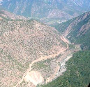
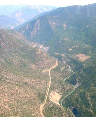
| The aerial view above takes in Camoo Crossing (at right) and the Applespring area (the benchland just above the centre of the picture. Hidden behind the flank of dryland mountain at centre-left are the canyon walls traversed by the road in the picture at left. The peak is Camelsfoot Mtn, one of the principal peaks in the range of the same name. At Applespring Creek, whose valley is in the left background, the Bridge River takes a sharp turn through a steep-walled gorge partly hidden from view above and followed by the road depicted at left. | |
Aerial pic from Photos by Kat |
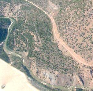
Just after the road towards Moha leaves the Applespring Bluffs the terrain below the road widens out into a sloping bench, as depicted at left. The serpentine road shown leads down to a small bridge known as Camoo Crossing, which serves as the only road crossing of the Bridge River between the Fishing Grounds and Terzaghi Dam. There is (or was) a forestry campground adjacent to the Camoo bridge which is very pleasant; the roads on the "wild" side of the river (the lower left of the picture) connect up to a large network of roads which interconnect with the powerline roads that roam the broad valley-side south of the river and up to the heights of Mission Ridge and (if not blocked by slides) to the Microwave above Shalalth. Mountainbikers who want to ride Mission Ridge may consider being dropped off at the summit of Mission Pass, then having their rendezvous-ride meet them here at Camoo where they can wait it out with some nice shade and some shallow rapids to fool around in. As suggested by the arid pine forest shown here, fire hazards in this region can be extreme so please use caution. |
Aerial pic from Photos by Kat |
Camoo Crossing is near dead-centre in this photo, although the Applespring area is out of view beyind the mountainside at left; the large cliffs visible are across the canyon from the road shown in the picture featuring Camelsfoot Mtn in the first picture on this page. Fountain Ridge and the Clear Range can be seen in the distance. This picture is really more illustrative of the broad basin of the Moha-Yalakom area but is given here to show the location of Camoo and Applespring relative to the Lower Bridge River (Xwisten community area), visible at rear left, and the country upstream. Moha is immediately beneath and a bit behind the aerial vantage-point here; Mt McLean is just out of view at upper right. |
 Photo: Mike Cleven These views are taken from the roadside in the Applespring Canyon stretch of Hwy 40; I'm not sure of the vertical drop to the river in the picture above but any local who knows is welcome to write me (replace "_at_" in address with @ symbol). The picture at right shows the sandy walls of the Applespring Canyon stretch of the Bridge, which are among the many "environmental relics" of the extensive hydraulic mining which hosed down riverbanks and benchlands from above Moha all the way down to the Fraser. The peak in the background is the southernmost of the Shulaps Range (Vast Mountain). |
 Photo: Mike Cleven |
 Photo: E. "Andy" Cleven |
|
 Photo: Mike Cleven |
| Low-lying canyons line most of the
tributary streams of the Fraser. The arid view at right,
surmounted by rocky and sometimes icy crags, is somewhat typical of many
such canyons in the Lillooet District, even
the smaller ones being quite grand - except for that it is a view of
the Bridge River's lower canyon (of several) from roadside in the
vicinity of Applespring Creek - looking straight down from more than a
few hundred feet up. The roadside this picture was taken from is
shown at right, if I'm not mistaken from one of the two corners visible
in the pic (not a good place to stop!), a narrow road carved into the
gravelly rock bluff just upstream from Applespring Creek; not sure of
the ID on the peak yet, but I don't think it's a major summit of the
Camelsfoot Range, although it could be a flank of Camelsfoot Peak.
Rugged stretches of the Bridge River like this one - once filled with
a large rushing river - remained immutable (and unexplorable) until
the canyon's emptying of its flow by the main generators of the
Bridge River Hydroelectric Development. Most of the lower Bridge
below Yalakom is now quiet canyon pools like the one shown at left -
although nearly all of the lower river is on the Bridge and any water
exploration or hiking requires the permission of the Bridge River
Band.
Before it was diverted into the Seton watershed in 1958, the Bridge River ('Xwisten in St'at'imcets) was among the largest (and most salmon-rich) of the Fraser's tributaries, and filled this gorge with a rush of blue-white water comparable in season to the Chilcotin or even the Thompson. The Bridge River originates in a massive icecap some hundred miles to the West of Lillooet that is the source of seven major Coast Mountain river systems, and during its course combines into itself several other large glacial streams - the main ones being the Hurley River (or "the South Fork of the Bridge" as it often appears on older maps), Gun Creek, Tyaughton Creek, and the Yalakom River, each with its own canyon within the Bridge's large highland basin, and all quite large in their own right. At the Bridge's mouth at the Bridge River Fishing Grounds on the Fraser, the river's waters roared into and atop the Fraser's own cataract, both rivers converging in a rocky double throat and sharp ledge. forming some of the worst water on the Fraser shy of the nearby Six Mile Rapids, or even Hell's Gate itself. The rocky step where the Fraser and the Bridge once so mightily converged was said to be of Coyote's own forging - so that salmon would be easier for people to catch.To this day it remains among the most important (and sometimes the most contentious) of the native fishing grounds along the Fraser, with today's families still occupying the particular fishing spot and fish-drying camp used by their families for thousands of years. Largely invisible from Highway 12 far above, the nearby Six Mile Rapids had an equal (if not larger) concentration of native fisheries shared by native families from throughout south-central BC, including Secwepemc (Shuswap), Nlaka'pamux (Thompson) and Okanagan). The Six Mile Rapids and Bridge River Fishing Grounds were also shared within the nearby St'at'imcets-speaking peoples, with chies and families from Pavilion Seton, D'arcy and Mount Currie having fishing privileges on the best fishing grounds on the Fraser alongside the people of the Bridge River, Lillooet, Cayoosh Creek and Fountain peoples. |
|