
BC Archives # I-22328

BC Archives # I-22322
| In support of my webspace rental fees pllease donate generously at GoFundMe or Patreon |
Thank your for visiting.
If you enjoy this site please make a donation. |
|
| BC Archives # I-22328 |
BC Archives # I-22322 |
Pavilion |
||
 BC Archives # D-02962 |
||
 Aerial pic from Photos by Kat |
||
 BC Archives # E-05604 |
||
 BC Archives # I-22331 |
 BC Archives # H-00638 |
|
|
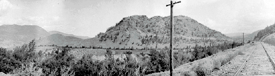
Pavilion lies about 20 miles upstream from Lillooet at the outlet into
the Fraser Canyon of the valley of Pavilion Creek, which begins in
the karst landscape of Marble Canyon and
connects through via Lower Hat Creek towards rhe Cariboo Highway and
the main part of the Interior. The picture at the top of
the page was taken looking up the Fraser from somewhere near Pavilion
along the PGE; the picture at above left is a
view of the lower benchland below Pavilion proper; the gorge in the
middle of the picture is that of the Fraser, which lies a thousand
feet or so below the lip of the benchland. The picture at above
right is a much older one taken a mile or so further south, also looking
north up the Fraser; the road in the foreground is the old Cariboo
Wagon Road, but is the same route as followed by today's Highway 99;
Pavilion Store and the village are to the right of the treed hill on
the picture's right edge; the PGE line is just visible on that same
hill, at the lower edge of the treed area. The Pavilion Store,
by the side of today's Highway 99, was the site of the 21 Mile
roadhouse of the first Cariboo Road; |
||
 BC Archives # I-22334 |
|
|
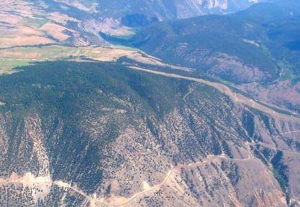
| This is of the valley of
Pavilion Creek, a few miles east of the store and village, and are part
of the Bryson Ranch, now the Termuende Ranch and for a while part of
the "Diamond S" ranch owned by Spencer, who also had bought the upper
benchland from the Carsons. The high wall of Marble
Canyon's north rim is the bluff at centre-right; Chimney Rock is
discernible immediately below and to the left of the bluff ("bluff" is
an understatement; the marble ramparts of the canyon soar thousands of
feet from the valley bottom). The summit of Pavilion Mountain is
the bulge at the left end of the ridge; some 9000+ plus in elevation;
the elevation of the farmhouse is in the 3000' range. The
buildings above are in the area of the fields in the valley in the
picture at right; just about where the second patch of sunlight begins.
The valley of Pavilion Creek, which is depicted here, is part of
the limestone karst topography which helped form Marble Canyon and is
associated as well with the Hat Creek lignite coal deposits nearby.
Pavilion Creek itself is intermittent, disappearing underground
for some of the distance between Pavilion Lake and its re-emergence in
the area of Pavilion Village. From there down to the Fraser it
cuts its own deep canyon with many waterfalls and deep gorges in a
rapid descent nearly 3000' to the Fraser. At the bottom is the
Pavilion Ferry, or rather where the Pavilion Ferry used to be.
Most of the bridges are washed out and there has been no
maintenance of this road in decades so the road is undriveable.
Mountain bikers and hikers may wish to try it, but must be
prepared for the long jourrney back up, especially in the summer heat
when even the shadows can be scorchingly hot. Experienced and
equipped outdoors people may wish to bring something to get them across
the Fraser; if the old ferry cables are still there, as they used to be
I think, they coulc be used for guide-stays to drag yourself along by.
The river is large and swift here, with dangerous rapids just
downstream, so this is not to be attempted lightly. The benefits
are a journey back down the Fraser to Lillooet - a dirt-road "circle
tour". |
||
 Aerial pic from Photos by Kat |
 Aerial pic from Photos by Kat |
|
| The high benchland that shoulders Pavilion Mountain was chosen for the route of the original Cariboo Wagon Road, which climbs up from Pavilion Store and the junction with the Marble Canyon Road to Hat Creek and Carquile, connecting with the newer Cariboo Wagon Road (from Yale via Spences Bridge and Ashcroft; the two Cariboo Wagon Roads met at Clinton). Mrs. Harris comments that it was somewhat surprising the Pavilion Mountain route for the Wagon Road was chosen, given the easier route available via Marble Canyon; apparently the technical difficulties of building along Moran's long talus ("scree") were too much even for the Royal Engineers, since the PGE route via Arden Forest, the narrow valley between Kelly Lake and the Fraser, has a much lesser grade than the long and very steep grades of the Pavilion Mountain route. The descent to Kelly Lake from the crest of the mountain ridge above the benchland is comparable in grade and number of switchbacks to the Mission Mountain Road, though with not as much difference in vertical, although the summit is much higher and must have been a strain on the animals hauling goldfields-bound loads. As with Mission Mountain, it's very taxing on vehicles although it remains a public road today - much of it on the original Wagon Road grade. As can be seen in these photos by the linear cut across the benchland, high-tension powerlines traverses the ranchland, coming from the Kelly Lake Substation and making high crossings of the Fraser at Pavilion and Glen Fraser, and then of the Bridge River near its mouth at the fishing grounds. There was an old fire lookout on top of Pavilion Mountain, accessible via roads in questionable condition branching off near the summit of the road; the mountain does not have alpine in the crag-and-ice sense, and its higher regions are hilly country riven by limestone valleys, the larger and southwesterly of which emerge in Marble Canyon, the biggest of them being the Great Cut. Pavilion Mountain as a land-mass is the southern terminus of the Marble Range, which continues up the Fraser past Jesmond to Dog Creek and forms the east wall of the Fraser Canyon throughout this stretch. Despite its containment within the triangle of Hwys 99 and 97 and the Pavilion Mountain-Kelly Lake Road, there's a surprising amount of wilderness in the central, higher parts of Pavilion Mountain and the country is very rugged and dangerous despite not being heavily mountainous like the Camelsfoot; hikers and mountain bikers should be aware of a high wildlife presence, and be on guard for grizzly, cat and wolverine - and hunters at appropriate times of year (as with most of the country on this website). Given the extreme karst topography of the Pavilion Mountain high country and Marble Canyon and the limestone composition of the whole Marble Range north towards Dog Creek, it's reasonable to suspect that there may be cavern or crevice systems here yet undiscovered, so anyone straying off the forestry and range roads in this area should be wary; caves should be considered to very probably be active lairs for something the unprepared individual will not want to encounter, so casual spelunkers should think twice about exploring this area. Similar dangers apply to climbers in the side-canyons off Marble Canyon. | ||
 BC Archives # E-05572 |
 BC Archives # NA-11079 |
|
 Aerial pic from Photos by Kat |
||
 BC Archives # I-22335 |
 BC Archives # I-22333 |
|
| The ranches at Pavilion are among the oldest spreads in BC. The upper ranch on the high benchland was founded by Richard Hoey (?) but was bought and developed by Carson in 1866 and stayed in that family until 1942 when it was bought by Spencer. In 1949 Spencer bought up the Bryson Ranch, which is the lower benchland and the lands in the valley of Pavilion Creek farther above. 26 Mile House was the old Carson ranch house, built in 1867, and was located on the upper part of Pavilion, located on the broad high benchland that stretches to the road summit of Pavilion Mountain (the actual mountain summit is some miles SE of the pass); the Carsons were known for their hospitality and their ranchhouse was one of the favourite stopping-places along the long journey from Lillooet to Barkerville. From the higher edge of this plateau, the Cariboo Wagon Road made a staggering switchback descent to the valley of Kelly Lake, which leads towards Clinton where it meets the newer Cariboo Wagon Road (and today's Highway (97) from Yale via Spences Bridge and Ashcroft-Cache Creek. A picture of Kelly Lake and its valley can be found just below, possibly taken from the Cariboo Wagon Road (I'm not sure; it may be looking back towards Pavilion Mtn in fact). | ||
| Aerial pic from Photos by Kat |
||
Pavilion Store & Village |
|
|
 BC Archives # D-08884 |
 BC Archives # I-22327 |
|
|
Pavilion is generally considered to be the eastern and northern
extremity of the Lillooet country, and this area also marks the
boundary between the St'at'imc (Lillooet) and Secwepemc (Shuswap)
peoples and languages; the native people of Pavilion call themselves
the Tskwaylaxw Nation and are related to both Lillooet and St'at'imc
peoples. The native village is glimpsed through the trees in the
old vintage photo at left; the picture at right was taken from the BCR line looking back down towards the
Pavilion Store, which the line passes in front of only a few miles back
down the track; the line does a horseshoe bend into the Pavilion village
area before climbing back out to the main valley of the Fraser at this
point; the village is out of sight to the left. For more information,
it is best to visit the Tskwaylaxw
Nation website directly. |
||
 BC Archives # B-02678 |
 BC Archives # B-02679 |
|
|
I've
never been down to the Pavilion Ferry, although once we followed the
old road down a few switchbacks by mountainbike but never made it past
one of the washed-out bridges across the hiden canyon of lower Pavilion
Creek . Knowing how far down it was (around 2500' vertical
from the Pavilion store), we reconsidered, and hiked back up the
lower canyon of Pavilion Creek instead. The ferry road
crosses and recrosses the creek and its canyon several times before
reaching the banks of the Fraser, where the above pictures were taken
(those horses are tired!). I'm not sure, but I think the
picture on the left looks to have been taken on the west bank, where an
equally long and torturous trail climbs up through the
vermilion-coloured rock of the Red Creek Canyon
(renamed Slok Creek by the Ministry ofForests in the mid'70s using the
St'at'imcets word for "red", even though that's not the St'at'imcets or Tskwaylaxw name for the
creek. The Pavilion Ferry's aerial system was only built in the
1950s, an older ferryboat operated here before then; erial ferries and
cable-drag ferries (using barges or rafts) were used on the Fraser at
several places north of Yale due to the river's turbulent and rapid
current. Note the boat in the picture on the right, which probably
was attached by tow-rope to the cable-ferry's platform for carrying
extra supplies or people across. I lived in that area for years, and can tell you that back in the 40's and early 50's, one had to leave their vehicles at the Pavilion store, which was owned by John Moss at that time, and walk about 4 miles back toward Lillooet, then follow a trail down to the ferry. (About another 4 miles.) The ferry in those days was a wooden rowboat manned with oars only. The ferryman, Tony Montgomery, would seat us in the boat, pull it up-river a distance, then push off and row to beat blazes to get across. In the early 50's, the highways department put in the road and cable ferry. The photo you show was the first cable 'car' we had, but it was replaced with a larger one with a hand winch set up in the centre of the 'car', and later had a briggs & stratton engine mounted under the winch. The next, and last 'car' was a heavier version of the one it replaced, but the engine was mounted on the top, above the cable, and drove the wheels on the cable itself, leaving the 'car' box open. In the
50's, Andy and Florence Hay bought the Pavilion store from John, and
ran it into the 60's sometime. The photo of the horses is correct, it
was taken on the west side of the river, but the man with his back to
the camera was Bert Gammon. He owned the old Montgomery ranch just
south of our place, and south of the ferry. Jim Akers, owner of the
old China Ranch to the north is standing beside his saddle
horse. I believe that one of the men on the landing was Buck
Akers, Jims son. Another man on the landing is possibly my
brother-in-law, Frank Christy, who owned his uncles place, the Dickey
ranch, again, south of the landing. The other man, I believe was Art
Heigh. He was the ferry-man at the time, and owned the Blue ridge ranch
directly above the landing. The Gammons brand is F3, Christys was
Diamond K, Heighs was BR bar. I don't know if Akers had a brand or
not. They must have. Diamond S was NEVER on the west side of the river.
Merle Gammon still runs the Gammon place, located between Blackhill
creek and Lee creek. Franks and my propertys both have been sold and
resold over the years, is located between Lee creek and Red creek. Red
creek was renamed by some hotshot surveyor for the forestry when they
surveyed the present day West Pavilion road in 1960, to Slok creek.
Thanks Bob! Here are some of Bob's own pictures of the Pavilion stretch of the Fraser Canyon and the old ferry connecting to West Pavilion, where he lived for many years: |
||
 Photo: Bob Wilson |
 Photo: Bob Wilson |
|
 Photo: Bob Wilson |
 Photo: Bob Wilson |
|
 Photo: Bob Wilson |
 Photo: Bob Wilson |
|
Slok Creek
|
||
 Photo: Mike Cleven |
 Photo: Mike Cleven |
|
 BCArchives # H-02933 |
|
| Marble Canyon is a narrow limestone gorge connecting Pavilion and the Lillooet country to the rest of the Interior via the Hat Creek basin. It is intrinsically interconnected with the placename 'Pavilion' - the ranchlands of the Pavilion comprise both the canyon's mouth and its edge, and the largest lake in the canyon's bottom is Pavilion Lake; the site of Pavilion itself is really the canyon's outlet onto the main Fraser Canyon. The photo gallery concerning Marble Canyon is very large, so I have created a separate Marble Canyon page. The above picture was taken - I think - from a hillside above the canyon's east end; Upper Hat Creek is to the left, and the Lower Hat Creek Valley stretches down to Carquile on Hwy 97, also known as Cottonwood House. | |
 |
There's nothing historical about this except in
a tabloid sense, but it's such an odd picture it had to be included. I
remember seeing this as a child; my father took the picture. The man
studying the crash is the attending RCMP officer; the school is in
the village of Pavilion on the Lillooet-Cache Creek road (then not yet
a highway and still pretty much the original Cariboo Wagon Road) and
just cross the rail tracks from the Pavilion Store. What was strange
about the crash is that the school stands in the middle of a large field
of alfalfa and scrub and you would have had to aim for the small school
building in order to hit it so precisely - my mom tells me it turned out
the pilot had been drinking, although if that's true or not I wouldn't
know for sure. Such one-room schoolhouses were common throughout rural
BC until the later 1960s (I know - I went to one). Needless to say,
this one got re-built and has since been replaced by a modern facility
on the same site. |