BC Archives #
I-57555 |

BC Archives #
NA-03634 |

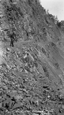
BC Archives #
I-57873 |
|
Oh,
it's hard to begin this page. Why a whole page for one geological
anomaly of near-purely local interest? Well, I guess it's because
there's lots of pictures available of it. One reason, though, part is
that those pictures haven't changed much in the last 100-odd years,
other than the quality of the (still shifting) road surface. This
is because the geology in question is unforgiving and the engineering
problem it poses remains pretty much the same - the mountainside it
crosses is "rotten rock" from the top of the ridge right to the river.
The diffference nowadays is that there's a bit of pavement on the
bit of road that straggles acrossit; the Slide has to be repaved every
so often because of all the falling-rock damage, and sometimes a
complete wipeout, but really it hasn't changed much from the days when
it was a rough and unsteady track carved across a scree as can be seen
in a few of these pictures. I think this is one of the only
provincial highways (No. 12) with an active rock-slide zone across it,
or rather built across an active slide; I stand ready to be corrected on
that, though. There are slide chutes on other highways (including
Hwy 99, especially on the Duffy
Lake-Cayoosh Canyon segment) but nothing so active as the Big Slide.
Situated on the southern end of Fountain
Ridge, the Big Slide is so active that rockfall is near-constant
and the road-surface has to be checked and maintained on a weekly,
sometimes daily basis. In the old days, the Lytton-Lillooet
Road didn't even try to cross it, but went instead via the Fountain Valley, in behind the ridge
the slide falls down off of, and up to Fountain
(Xaxl'ip) and back down the Fraser to Lillooet from there.
Although there's been a road across the slide since the 19th
Century, most traffic went around via Fountain
because of the dangers of crossing the Slide.....all 50 meters of
it......It's still a bit of a death-defying passage, but a glance at
some of the older pictures here gives an idea of exactly how much it's
been improved. Not fixed, but at least improved.
One of the classic stories I heard about the
Big Slide (over and over, from my Dad) concerns some locals who
stopped for a pee back in the '50s in the middle of the Slide.
Talk about a death wish. Anyway, while they were heeding
nature's call there was a loud "crunch". A boulder several times
the size of their vehicle had crushed it; thankfully everyone was
"enjoying the scenery" at the time......
Road hazards in the Lillooet region can still be extreme. In some
specific spots, going off the road means that you might not be found for
days, perhaps weeks or years, because of the deep gorges on some
corners, or simply of the power of the river far below which would sweep
you away if you went in. When I was living in Lillooet in the '70s
a vehicle went off into the Gibbs
Creek Canyon near 12 Mile (below the Fountain BCR tunnel); one
survivor managed to climb up to then-Hwy 12 (now Hwy 99), taking 3 days
to do so; the vehicle was several hundred feet or more below in a narrow
canyon, invisible from the highway, and is still there to this day......
Maybe because he was an engineer, my Dad had a particular fascination
for the Slide and I seem to have lots of memories of my Mom bugging him
about not stopping on it for any reason, but more often than not he'd
stop and take some pictures, a few more of which follow below.....
|
|

BC Archives # B-01920 |

BC Archives # I-57556 |

BC Archives # I-57557 |
|

 BC Archives # C-09842
Photo: R.H. Morgan 09/47
BC Archives # C-09842
Photo: R.H. Morgan 09/47


