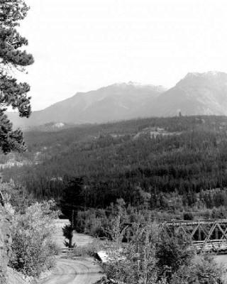
BC Archives # I-22303

Aerial pic from Photos by Kat
| In support of my webspace rental fees pllease donate generously at GoFundMe or Patreon |
Thank your for
visiting. If you enjoy this site please make a donation. |
|
BC Archives # I-22303 |
Aerial pic from Photos by Kat |
 BC Archives # F-04087 |
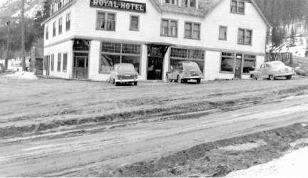 BC Archives # E-05214 |
||||
 |
|||||
| The bridge at the top of this page, over the Bridge River, gave the town of Gold Bridge
its name, even though the town proper lies about a mile up to the left
across the bridge. The locality visible in the Bridge is called
Haylmore (pronounced Haleymore by older locals) and beyond it in this
view is a locality called Southfork, which is the location of the main
operating placer mine in the area today,
immediately at the mouth of the Hurley Canyon
,which is the gorge wall visible in the centre-right of the
picture. The cabin of Will
Haylmore, famed assay officer and mines officer for the district,
lies hidden from view behind the bridge, but lay just past the bridge's
abutment. In more recent times this area served as the location
for the community baseball diamond as well as a few residences and a
horse paddock, but was inundated by floods that issued from the Bridge River and the Hurley
(properly the South Fork of the Bridge River, and almost as large as the
main branch that comes out of Downton Lake via Lajoie Dam). The
road from the hither side of the Bridge leads towards Lajoie Dam and the Gun
Lakes to the right, and Tyax and Lillooet to the right. In the
lower reaches of Hurley Canyon are a network of mine trails and old
roads that lead to various small diggings in the canyon wall, and some
small hardrock exploratory diggings continue there today. It is a
tough eight miles upstream to the base of Hurley Falls, which lies in a
tree-shadowed gorge just downstream from the river's confluence with the
Cadwallader just below Ogden.
Gold Bridge is the largest of the Bridge River communities today, and
its central location within the region along the route of the Hurley Main road from Pemberton probably means
it will be the focus of increasing development in the valley in coming
years. Located near the confluence of the main Bridge River with
the South Fork of the Bridge River (usually known as the Hurley River),
Gold Bridge was essentially a base town for the company towns of
Bralorne and Pioneer, as well as for the many small mines, lodges, and
hunting outfitters and other recreational operations in the
region. A little more rough around the edges than the strict life
of the company-run towns, Gold Bridge had an unhealthy supply of
saloons and other such ventures, including a couple of "sporting
houses", as well as a variety of services related to the mining and
outfitting businesses. The bridge depicted below is the
Gold Bridge, as it's known, the low-lying locality shown here just
across the Bridge River known as Haylmore in honour of that Gold Bridge
neighbourhood's most distinguished resident, mining recorder Will Haylmore. The cleft in
the centre-right of the picture is the opening of the Hurley Canyon,
through which the South Fork/Hurley runs after its confluence with
Cadwallader Creek about eight miles up (the road past Brexton to Bralorne
runs along the left side of the canyon rim). Just below the
canyon's mouth is a rich placer claim still in
operation today. |
|||||
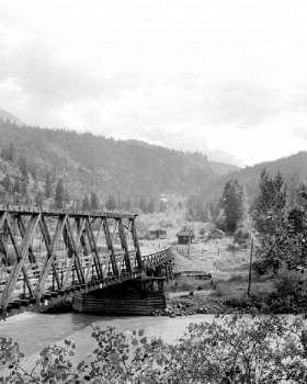 BC Archives # I-22302 |
This is another view of the bridge over the Bridge River that gave the town of Gold Bridge its name, even though the town proper lies about a mile up to the left across the bridge; apparently it was once painted "gold" (yellow) although whether this was to salute the town's name or was the source of the name I'm not sure. The locality visible in the Bridge is called Haylmore and beyond it in this view is a close-by locality called Southfork, which is the location of the main operating placer mine in the area today, immediately at the mouth of the Hurley Canyon ,which is the gorge wall visible in the centre-right of the picture. The cabin of Will Haylmore, famed assay officer and mines officer for the district, lies hidden from view behind the bridge, but lay just past the bridge's abutment. In more recent times this area served as the location for the community baseball diamond as well as a few residences and a horse paddock, but was inundated by floods that issued from the Bridge River and the Hurley and covered in gravel and other debris (the Hurley is properly the South Fork of the Bridge River, and almost as large as the main branch that comes out of Downton Lake via Lajoie Dam). The road from the near side of the Bridge leads towards the Dam and Gun Lake to the right, and Tyax and Lillooet to the right. In the lower reaches of Hurley Canyon are a network of mine trails and old roads that lead to various small diggings in the canyon wall, and some small hardrock exploratory diggings continue there today. It is a tough eight miles upstream to the base of Hurley Falls, which lies in a tree-shadowed gorge just downstream from the river's confluence with the Cadwallader; if Hurley Falls were more visible it would be one of BC's more famous waterfalls, as it's very powerful and thunderous; worth the hike from Bralorne if you can find the way. |
| |
 Photo: E. "Andy" Cleven |