
McNeils & Seton Bluffs

Photo: Mike Cleven
Aerial pic from Photos by Kat
| In support of my webspace rental fees plleasedonate generously at GoFundMe or Patreon |
Thank
your for visiting. If you enjoy this site please make a donation. |
|
|
|
McNeils & Seton Bluffs
|
|
| Photo: Mike Cleven |
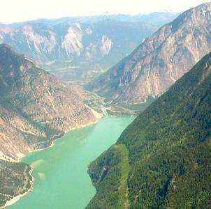
These staggering bluffs tower around 6000 feet over the eastern section of Seton Lake at a place called McNeils, which was once one of the main villages of the Lakes Lillooet. Above these cliffs are the alpine meadows and bowls of Mission Ridge, and behind them is the gorge of the Bridge River Canyon; the British Columbia Railway skirts the water's edge at their base, in some places being built on piers into the water's depths. The cliffs are visible from the eastern end of the lake, but only the part on the right in this photo is visible from that direction. Note the pointed spire to the left of the summit; viewed from closer up it is a huge spearhead overhang; a major rock chute lies beneath it in this picture's shadows. The treed area on the left was created as a rock talus from the erosion of these cliffs and is the location known as McNeils, which is an Indian Reserve but also once had had a small resort called McNeils Lodge. |
Aerial pic from Photos by Kat |
 Aerial pic from Photos by Kat |
 Aerial pic from Photos by Kat |
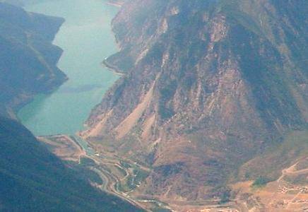
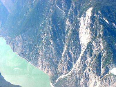
| These two aerial views give reverse
perspectives on the location of McNeils and its relation to the Seton
Bluffs which overhang it. In the picture at left, looking nearly
straight down, shows the "fan" that forms McNeils in the centre-bottom
of the picture,which shows the rock chutes from the Seton Bluffs which
are obviously still active and a danger to rail traffic as well as to
the safety of any residences in McNeils. In the picture at right,
taken from just above the Lillooet Spires (the pointy crags above the
town of Lillooet) McNeils is the bulge on the right-hand (north) shore
of Seton Lake, but the Bluffs which tower
above McNeils are not visible here, although the peak of Mt McLean and
the other summits of Mission Ridge are.. Carpenter
Lake is partly visible in the left-rear background. |
|
 Aerial pic from Photos by Kat |
 Aerial pic from Photos by Kat |
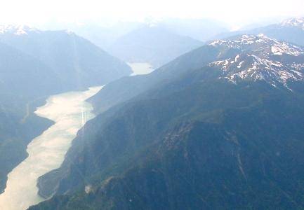
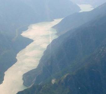
| The picture at left is a closeup taken from
the image just above and on the right, which is given here to give a
slightly better view of where a
dramatic cliff rises out of the southern shore of Seton
Lake - at mid-left centre - but it is obscured by shadow here.
These bluffs are also hinted at on the right-hand (south) shore in the
picture at right, which also gives a clearer view of McNeils - left
foreground and its location relative to Skimka (Seton
Beach), and Nkoomptch (the gorge of Seton
Creek). In the picture at right, Lillooet
is out of view around the flank of the mountain, although the airport
and much of East Lillooet is visible beneath the crags of Fountain Ridge (in the background).
The farthest mountains visible are those of the Clear Range behind Fountain Valley, which form the western
rim of the Hat Creek Plateau. |
|
 |
This
is a view of the Seton Bluffs taken from Hyw 99 (the Duffey Lake Road)
just above Skimka (Seton Beach).
McNeils is out of view to the left; the high summit at upper left is the
flank of Mt. McLean. If you
look carefully (easier in the larger version accessible if you go to
the large-format image by clicking on this one) you can get an idea of
the scale of these cliffs, as a BCR freight train
is following its track along the shore of Seton
Lake. It is completely dwarfed by the immense mountainside
which soars above it. |
Mission Ridge |
|
 Aerial pic from Photos by Kat |
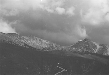 |
| These pictures are both of the western end
of Mission Ridge, just above Shalalth.
The Mission Mountain Microwave is just inside the lefthand side of the
image at left, with the walls of the Bridge River
Canyon visible just behind; a better view of the Microwave's
location can be seen in a similar picture on the Mission Mountain Road page. The
powerlines which run the length of the ridge (on the leeward side,
behind the crags) are mostly not visible but can be just barely seen in
the large-format version of the same picture (which you get to by
clicking on the image above). The picture at right is my own,
taken near the summit of the Mission
Mountain Road, showing a peak of Mission Ridge known to Setonites as
"the Teat" but which has another native name meaning the same thing
which I'll find out before next revision of this page. Mission
Ridge does not really have any peaks in the usual sense, but is rather a
short range of high alpine basins and domes and half-domes, with crags
falling off towards the Seton Lake side.
There are numerous legends and rumours about the ridge but none I'd care
to repeat here without consulting elders and old-timers to get them
straight first. 4x4 roads traverse the back side of the ridge, and
it's possible to drive from the Mission Mtn Microwave to Moon Lake and
the Camoo Crossing of the Bridge River,
and also to follow the powerline all the way to the Bridge
River's junction with the Fraser at Sxetl. Winches advised
for much of this, and it is probably a better idea to rely on
mountainbikes or dirtbikes because of the extreme road conditions you
are likely to encounter. The ridge is very windy and suscept to
extreme changes in weather, even in summer, so hikers and others are
advised to come prepared for heavy weather - as well as for dangerous
wildlife. As the ridge is near-entirely in Indian Reserves
controlled by the Seton and Bridge River
Bands, it is advisable to obtain permission from local band offices
before any extended hiking or camping; and it is always a good idea -
and legally mandatory in fact - to notify someone of your route,
destination and planned length of stay/hike for possible emergency
rescue reasons. Mission Ridge is not the highest range in the area
- one of the lowest actually - but it is nonetheless not a place to be
taken lightly by casual hikers. Telemark and cross-country skiing
in dry powder is probably very attractive in winter, but wind and
avalanche dangers should be considered to be extreme, and search and
rescue difficult because of the ridge's complex weather patterns. |
|
 |
|