Aerial pic from Photos by Kat

Rex Peak
|
|
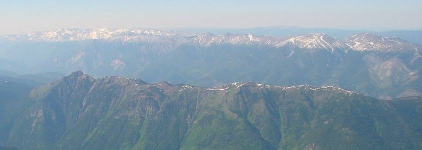
 Aerial pic from Photos by Kat These two images are from the same frame - the one at left being a cropped closeup of the one at right. Rex Peak, or Rexmount, is the triangular or conical peak just right of centre of the picture. Like Shulaps Peak, here looking like a roundish flat summit at left, it dominates the eastward view of the range from the upper Bridge River Valley. |
 Aerial pic from Photos by Kat |
| One of the lower cliff-faces visible here is depicted just below, and while dwarfed by the peaks above it still towers impressively over the Rexmount area of the Bridge River Valley. The road diverging from Highway 40 at right is the Marshall Lake Road, now a logging main which leads into the Tyaughton-Mud Lakes area. The snowy mountain in the background is Nine Mile Ridge, one of the northerly and higher areas of the Camelsfoot Range. | |
 |
|

Vast Mountain-Hell CreekThese views are of the ungazetted peaks at the southeastern end of the Shulaps, the one on the right having acquired the name Vast Mountain as bestowed by a homesteader who lives on Michelmoon Creek, which flows steeply into the Bridge River Canyon just above Moha. I seem to recall hearing it called "King of the Canyon", but that may just have been my Dad's nickname for it. |
|
 Aerial pic from Photos by Kat |
 Aerial pic from Photos by Kat |
|
The photo at left is taken from above Carpenter Lake; the photo at
right from above the south wall of the canyon. The clearcuts at
right are in the upper valley of Hell Creek, another canyon-creek
tributary of the Bridge River, which is also the site of a formerly
producing jade mine, which is the sloping cleared patch just to the left
of the clearcuts; more easily seen in certain other pics below. |
|
| Now
this is the improbable part about the Hell Creek Mine - and there's no
visual proof of it in the pics so far but plenty on the maps and in the
history of the mine - but access to the mine was made over the alpine
pass visible to the left of the peak here - the mine is off to the
right. Access was via Blue Creek from around the Yalakom side,
cutting off the main Yalakom road a few miles north of Moha; there was
no possible access to the mine from below, even though logging roads
have since climbed up there from the Bridge River
Canyon.....some boulders of jade were choppered out, rather than
trucked, in order to preserve their size and also to prevent
cracking. The snowy summit in the background here is nine Mile
Ridge of the Camelsfoot Range; the low conical peak at far left
background is China Head (not
China Hat like some eco-pamphleteers haev put it!). |
 Aerial pic from Photos by Kat |
|
|
 Photo: Mike Cleven |
 Photo: Mike Cleven |
 Aerial pic from Photos by Kat |
 Aerial pic from Photos by Kat |
| These are only peripheral views of the
Shulaps Range, the southernmost tip of which is the ridge in the
foreground; the remains of the Hell Creek Jade Mine are the snowy patch
in the col. The lake visible is Anderson Lake, the range behind it
being the D'arcy Range, a subset of the Cayoosh Range. The ridge
immediately behind it plus the peaks and ridges to the right of Anderson Lake are components of the Bendor Range; the others to the left beyond the
valley the lake is in are the Cayoosh Range,
with the Joffre Range showing as the distant
trio of peaks in behind. The roundish ridge at near left is the
eastern end of Mission Ridge; Mission Pass lies in the low gap between
it and the nearest bit of the Bendor, which
is the flank-ridge of Nosebag Mountain. These shots were taken
from directly over the Bridge River Canyon. |
|
Shulaps Peak |
|
 Aerial pic from Photos by Kat |
 Aerial pic from Photos by Kat |
| Now, I'm going out on a limb here because
I'm only familiar with the appearance of Shulaps Peak, the range's
highest, from the direction of the upper Bridge River basin, and this
from the exact opposite, but I'm pretty sure it's the one that;s
featured in the centre of the picture at left, and at extreme left in
the picture at right; sort of flat but still snaggle-topped and pretty
much the highest thing around, and pretty barren and wind-swept.
People familiar with the range are welcome to correct me on this one -
as with any location or description given in this whole site! If
I'm right, the trinagular peak at extreme left in the left-hand picture
is Rex Peak. The range in the left background
of the left-hand picture and the centre-background of the right-hand one
is the Dickson Range, the triangular peak
that crowns it being Mt. Dickson,
the spur at the left-hand end of the range being Mt. Penrose, above the Gun Lakes. The low range visible in the
right-hand picture, in between the Dickson Range and the Shulaps, is the Eldorado Range, with Relay Mountain being the higher round
summit to the right, just behind the v-notch of the bowl/col in the
Shulaps; Eldorado Mountain, just
above Tyax Resort and Tyaughton Lake, is the flattish
summit to its left; it's gazetted as a peak but doesn't look like one
much from here. |
|
 Aerial pic from Photos by Kat |
I think
the crags at left belong to Shulaps Peak in this shot of the central
massif of the Shulaps; Big Sheep and Big Dog Mountain
are off to the right. The range in behind is the
Bendor, with Mt. Truax at far left, Mt. Williams being the highest one and
(I think) Mt. Bobb being the one in the
left-centre of the background; if that's correct guesswork, that's the
flank of Whitecap Peak at extreme left. The mountains beyond are
the Birkenhead Ranges, in the centre
anyway; the tiny bit in the distance at left may be part of the Cayoosh. |
 Aerial pic from Photos by Kat |
This
is very similar to the shot at upper right, showing (if I'm right) Shulaps Peak to the left and what I think is Big Dog, or one of Big Dog's unnamed neighbours,
off to the right. In this shot, the Dickson
Range is in the left background; the Warner
Range, one of the highest subsets of the so-called Southern Chilcotin Mountains, is at extreme
left. The 1280x960 pixel original of this at No. 107 on http://www.telemark.net/~randallg/20021102_lillooet/ gives an amazing panorama of the ranges that make up one of BC's newest provincial park. Details available in the higher-resolution image include the Lillooet Crown Icecap just left of centre (here a dim white glow) and, as noted, the Warner Range at left, beyond which is the REAL Chilcotin (the Bridge River Country is NOT part of the Chilcotin, despite "urban environmentalists" renaming of it as such, and the government doggedly following suit when the park was created. The Shulaps and Camelsfoot Ranges are technically part of the geographical unit known as the Chilcotin Ranges, but the Shulaps and the Yalakom Valley are no more part of the Chilcotin than the Dickson Range or the Eldorados are..... |

Big Dog and Big Sheep Mountains |
|
| The panorama above is wider than even a 1024 resolution screen will handle, but it's got so much detail on its edges I didn't have the heart to break it up; it's a zoom-in on the 097 shot above in the Big Dog Mountain section, and is looking straight down the strike of the Shulaps Range. Big Sheep and Big Dog Mountains are in the foreground, with Shulaps Peak and Rexmount hidden in the massif just right of centre - Rex would be the pointiest peak at the left-rear of the massif, I think, although that might be Shulaps Peak looking along the length of its spine, which appears trapezoidal in the pictures above. The snowy lower crag at left is (I think) Yalakom Mountain, above Moha, the snowy bit to the left of it is Camelsfoot Peak down nearer Applespring. The hazy low range in between Yalakom Mountain and the Shulaps is Fountain Ridge, the Chipuin Mtn area of the Clear Range to the left of it and behind Camelsfoot Peak amd Yalakom Mountain. Mt. Brew is just visible beyond the central massif of the Shulaps, and to the right of the massif in the background is the Cayoosh Range. The "near background" range at extreme right is the Bendor Range, with the low summits in the hazy mid-foreground being the lower "foothills" of Rex Peak visible in the Rexmount section above. This picture was taken on November 2, 2002, so the full blast of winter's not yet on the Shulaps or its neighbours; still, the snow doesn't get much deeper than shown here due to the incredible aridity of the winds after they've comeover the ranges between here and the Coast; the Camelsfoot Range and this northernmost part of the Shulaps doesn't often get much snow at all, despite incredibly bitter subarctic cold at these altitudes in the Interior. | |
 Aerial pic from Photos by Kat |
 Aerial pic from Photos by Kat |
| |
|
| The
picture at right is the image from which the panorama at the head of
this section was cut. It shows the plateau at the upper end of the
Shulaps well, including of course the extensive clearcuts that have
taken place in this once-remote region in the last twenty years.
Poison Mountain, which is just to the left of this vantage point, is
generally assigned as part of the Camelsfoot Range but it really marks a
point where the Shulaps and the Camelsfoot merge; north from Poison
Mountain the designation Camelsfoot Range continues past Red Mountain
and to Black Dome and ultimately to one last flat butte north of that,
just shy of Gang Ranch. A couple of flat summits in the plateau
area shown are named Buck Mtn and Quartz Mtn, but I'm not sure how to
pick them out; we drove across here in a Ford Econoline back in '82 or
so, long before logging mains got up this far, just following old mining
roads - and wound up at the bottom of the infamous Churn Creek Hill for
our trouble, rutted out and waiting for a tow; this was the back end of
the world in those days; now it's probably a pretty easy drive but I
haven't tried it but might this summer. |
 Aerial pic from Photos by Kat |
| The view from the plateau shown here takes
in the whole upper Bridge River Basin, including the so-called Southern
Chilcotin Mountains, and also one of the more striking views of the
Bendor I've ever seen, but the most amazing part for me was seeing the
northern horizon - a rare sight anywhere in BC! - and the deep gorge of
the Fraser's big trench cutting into the Interior Plateau to the east of
here. A gold prospect here in the late '30s (early '40s?)
generated a lot of excitement, and there was talk of building a road to
access what would have been the new minetown near Liza Lake either
via this area or another higher pass farther down the range, since the
Bridge River Canyon was an unbuildable route and remained so until the
1950s. The prospect didn't play out and has long since been
forgotten, like many, including another at Black Dome. More about
the Black Dome strike and one-time plans for a copper smelter at Poison
Mountain will be found on the Camelsfoot Range page once I get time to
research and write that up. |
|
 Aerial pic from Photos by Kat |
|
 Aerial pic from Photos by Kat |
The
panorama above is excerpted from the image at left, which was taken
from above the end of Carpenter Lake above Gold
Bridge, looking ENEand showing the main peaks of the Shulaps; "Vast Mountain" is hidden but its very top spires are
visible in the original. That's Mission
Ridge at far right. Gun Creek and Tyaughton Lake are behind
the ridge in the right foreground. The bare patch beneath the last
main peak at centre-right are the bluffs depicted in black-and-white in
the Rexmount section. |
 Photo by Kat |
|
| This is a closeup of the Truax-Williams summits of the Northwest Bendor, but in the background there's a pretty
good view of the Shulaps, save for the bit that's obscured behind the
peaks at right. The pyramidal peak at left of centre is Shulaps Peak - I think - while Big
Dog and Big Sheep and the more northerly part of the massif are to
the left; "Vast Mountain" above the Bridge River Canyon is mostly hidden at
right. The pass at mid-left is above Liza Lake/Liza Creek, I
think, where gold hopes were once high, and through there a road might
have one day been built; it's one of the only passes through the
Shulaps; the other is at Noaxe Creek, farther to the left. The
range visible hazily through that pass is not the Camelsfoot, I think,
but rather the Marble Range on the
other side of the Fraser, in the area of Pavilion
Mountain. Again - I think
I've got these descriptions right - people more familiar with the range
are invited to write me with
corrections and comments (replace "_at_" in address with @ symbol). |
|
 |
|
| This is a view of the very northern end of
the Shulaps, which is about the right-hand half of the background here;
the main summit showing is (I think) Big Sheep Mtn.
This aerial is taken from over the Relay
Mountain area of the Eldorados;
in the valley in between are the headwaters of Tyaughton and Churn
Creeks, and off to the left the vast swamps and plateau of the
country towards Big
Creek, now a Provincial Park. The snowy summits at extreme
left are Red Mtn (at the picture's edge) and Poison Mountain. The low
pyramidal summit in mid-photo is Quartz Mtn - I think - with Buck Mtn to
the right of it (also flat but snow-covered here). The
snow-covered area behind these two in the distance is Nine Mile Ridge,
one of the many flat summits of the upper Camelsfoot. |
|
